Author(s): BV Lakshmi
Soft-sediment deformation structures were identified along Nandakini River valley near Chamoli village of Garhwal Lesser Himalaya. The deformation, in each outcrop, is restricted to a single stratigraphic layer bounded by undeformed flat-lying layers, eliminating the influence of slope failure. The structures are multiple liquefaction features like sand dikes, flame structures, pear-drop disturbance and downward warping of beds. The preferred interpretation is that the deformations resulted from earthquake-induced liquefaction and their existence adjacent to the Nandaprayag Fault can be related to episodic seismicity that occurred along this fault. However, more data and dating technique is needed to constrain the timing and distance to the causative seismic source. It is possible that more than one earthquake has effected the deformations.
The information about past seismic activity can be inferred from the soft-sediment deformational structures (seismites) in the late quaternary geologic record [1]. In seismically active regions, the seismites formed during or shortly after deposition are important indicators of paleoseismic activity [2-4]. There is no standard terminology to describe these seismites [5]. But different individual studies can be used to infer a formal geometric classification to describe the observed structures. The sedimentary features that form from the escape of pore fluids, usually water, occur commonly in fine to medium grained sand and these structures are a direct response to processes of fluid escape during liquefaction and fluidization [5]. The deformation structures attributed to seismic activity are (1) ball and pillow structures, pseudonodules or cycloids, pinch and swell bedding and lenticular boudins, pocket and pillar structures and flame- like structures [2,6-8]. Deformation structures linked to seismic shock can play an important role in analyzing the distribution and intensity of ancient tectonic activity [9,10]. A direct relationship between earthquake occurrence and the resulting deformation of the sediments has been invoked by various workers [2-4,9-12].
The criteria given by Sims, used to identify soft-sedimentary deformation structures produced by seismic event are as follows: (a) they occur in seismically active areas (b) structures should be confined to single stratigraphic layer separated by undeformed layers correlatable over large areas, (c) the layers are flat and horizontal to preclude the influence of slope failure, (d) the structures are similar to those described by Sims or formed experimentally by Kuenen, and (e) potentially liquefiable sediments of lacustrine origin are present [9,10,13].
The purpose of this paper is to enhance a database on paleo- earthquakes in the Himalaya using evidences of soft-sediment deformation structures. In the course of our investigations we come across a few examples of deformational features like pear- drop, sand dikes, and downward warping of beds in excavated unconsolidated sediments of the Nandakini river near Chamoli area along the active Nandaprayag fault (Figure 1b).
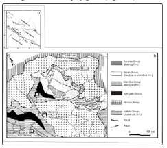
Figure 1: (a) Broad Tectonic features of Garhwal Himalaya (b) Geological map of the area around Chamoli (after Valdiya, 1980). 1,2,3 and 4 are trench sites
Situated in the Lesser Himalaya, the Chamoli area is bounded in the north by the active zone of main Central Thrust (MCT) and in the south by Main Boundary Thrust (MBT) (Figure 1a). The MCT is believed to have developed by an intra-crustal thrust, which brought up the mid-crustal level rocks of the Higher Himalayan Crystallines to the Lesser Himalaya. The MBT is a brittle fault with various signs of ongoing activity.
The Chamoli area forms a part of the tectonically intricate belt of the Lesser Himalaya, which is characterized by several nappes, klippen, windows and schuppen separated by various thrusts and fault zones. The major lithotectonic units in the area include: (1) the autochthonous units of the Damtha and Tejam groups of the Precambrian sediments exposed in the window north of Chamoli (Pipalkoti window); (2) the Berinag Nappe made up of the Jaunsar group of sediments, predominantly of quartzites (Berinag Quartzites), exposed south-west of Chamoli; (3) extensions of the Ramgarh Nappe consisting of crystalline rocks of metasediments and acidic intrusives and covering parts of Berinag Nappe and Pipalkoti window; and (4) the Klippen zones of Almora Nappe made up of the medium grade metamorphics covering a large part of the area (Figure 1b). The base of the Almora Nappe is variously called as the Munsiari Thrust, Baijnath Thrust, etc. in its different klippen zones. The NNW-SSE trending Nandprayag fault is the extension of the Baijnath Thrust. Further north, near Joshimath, the upper boundary of the Almora Nappe is demarcated by the Vaikrata Thrust or Main Central Thrust.
The Chamoli area is considered a schuppen zone and is delimited on two sides by almost vertical faults, viz. the alakananda fault running E-W in the south and the Nandaprayag fault trending NNW-SSE in the east (Figure 1b) [14]. The Nandaprayag fault as the most active fault of the region responsible for recurrent landslides and earthquake hazard [14]. The deformation features identified in the present study lie within the vicinity of this fault.
The Himalayan earthquakes are damaging a large and densely populated region of the subcontinent. Large scale thrust faults like MCT, MBT, HFT as well as transverse and normal faults are seen to control the present day seismicity and are the seismic centers of major and large earthquakes in north-west Himalaya. Tectonically, MCT represents a ductile shear zone at depth, comprising a duplex zone with three distinct sub-thrusts: MCT I, MCT II, and MCT III.
Historic and instrument data suggest fewer large earthquakes occurred in the region compared to the rest of the Himalaya. The Garhwal sector of Himalaya is known for high level of seismic activity and the earliest record of catastrophic event record dates to 1803. The M6.5 Uttarkashi earthquake of 1991, centered about 70 km north-west of Chamoli town, is considered to be associated with MCT I. The Chamoli earthquake of 29th March 1999, whose epicenter lay 80 km west of Tehri, killing about 100 people and injuring hundreds more, is an important event from the viewpoint of Himalayan and subcontinental seismotectonics. This quake occurred in the Central Himalaya, which is highly prone to earthquakes and has been placed in the highest seismic zone (zone V) of India. A sharp contact of MCT I with recent / sub-recent deposits is identified near Chamoli on the southern flanks of the anticline along the Alaknanda river [15]. This contact is interpreted to be the surface expression of an active fold.
In the Chamoli region a variety of soft sediment deformation features have been observed at four trench sites along the bank of the Nandakini River (Figure 1b). In each outcrop, deformation is restricted to a single stratigraphic layer bounded by undeformed layers and the layers are flat-lying, eliminating the influence of slope failure.
Trench site 1 (Figure 1a) shows syncline type slump structure in laminated sand, which is pear-drop shaped (Figure 2). Small-scale folds and faults are also discernible in silt and sand. Competence is a key factor in play that determines the character of deformation of different layers. The stretch shown in Figure 2 underwent folding, after which it got displaced to the tune of a few mms resulting in a few normal faults and microfaults. Faulting is confined to only the silty part along which slumping is seen to have taken place. The faults are a post depositional phenomen wherein the normal faults show displacement. The faulting in the sediments takes place because of the shaking effect, which destabilize the granular framework causing the sediment to behave as a liquid. Some ball-and-pillow structures are also seen [5,11,16].
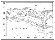
Figure 2: Slumping forming pear-drop structure with microfaults Trench site 2 is located at Jakhini village along the Nandakini River (Figure 1b). Here the coarse material has sink down into the clay to define a synclinal warp (Figure 3). It can also be seen that the lowermost clayey bed remains undeformed or is slightly deformed. Similar features are also observed in Figure 4 (trench site 3, Figure 1b). Both these deformed features, sinking of coarse sand into the clayey matrix, are similar to the structures described by Scott and Price [17].
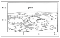
Figure 3: A slumping with synclinal warp at site 2
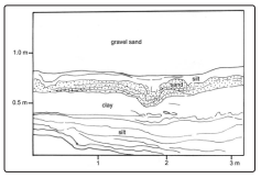
Figure 4: A slumping with synclinal warp at site 3
Figure 5 (trench site 4, Figure 1b) reveals silty material has been injected into the overlying coarser sandy unit forming a flame structure. Micro-diapiric intrusion is seen at some places and pseudonodules (cycloids) of coarse sand are also seen. All these structures are bounded by undeformed strata. The sand overlain by silt (at the bottom) and silt overlain by sand (at the top) is intruded upwards in the form of veins due to differences in density gradient and shear stresses due to differential porosities of the two lithounits, viz. sand and silt. It should be noted that density inequillibrium results when coarser and denser sediment overlies a finer and lighter one [2].
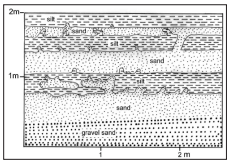
Figure 5: Hydroplastically injected flame structure at site 4
Soft sediment deformation structures developed due to vibrations that destabilize the granular framework causing the sediment to behave as a liquid. In the process of deformation, the soft sediment layers of different density break up and either descend or ascent through adjacent layers forming typical flow and injection structures [5,9,11]. Several trigger mechanisms that initiate soft- sediment deformation include: rapid deposition of sand, storm currents and gravity driven density currents and earthquakes [18,19,10]. Earthquake induced deformation structures have been shown experimentally to occur under conditions of earthquake- induced liquefaction [13]. Soft-sediment deformation structures found in this study are restricted to individual stratigraphical layers and are separated by undeformed beds extending over a large area. These deformation features of the Nandakini valley of Chamoli occur in tectonically and seismically active zone along the Nandaprayag fault. Hence it is proposed that their formation may have been triggered by past seismic activity related this fault in this region. Dikmen and Ghaboussi have shown experimentally that liquefaction results from the cyclic vibration of a saturated sediment column [20]. Most liquefaction is thought to occur either at or close to the surface in sediment layers with an overburden of less than 10-15 m [21]. Also, for a seismic shock to initiate the liquefaction, it has to exceed certain threshold intensity. A relationship was found to exist between the Richter earthquake magnitude and the maximum distance from an epicenter within which liquefaction may occur [22]. Earthquakes of a magnitude less than 5 cause little or no liquefaction; magnitude 6 cause liquefaction within a radius of 4 km; and magnitude 7 initiate liquefaction within a radius of 20 km [17]. Morgenstern has shown that during an earthquake the induced shear stress dissipates rapidly in near-surface consolidated sediments [23]. Thus, the stresses induced from aftershocks and low-magnitude earthquakes (less than 5) are weak and not do leave any signatures of sediment deformation. Tinsley et al., on the other hand, suggested that significant liquefaction phenomena can occur only with seismic events having a magnitude greater than 5.5 and 7.5 magnitude events, liquefaction can occur up to 100 km from the epicenter [24]. Cyclic loading and undulatory motions unleashed by the passage of surface Rayleigh waves also cause liquefaction [9,10,25].Thus from the foregoing it can be presumed that the deformation structures formed near Chamoli were effected by earthquake (s) of magnetitude ≥5.5 since (a) they show similarity to other known occurrences of earthquake-induced structures, (b) the features lie adjacent to the Nandaprayag active fault, (c) flat topography, and (d) lateral extent of deformation.
The deformation features along Nandakini River near Chamoli are formed by earthquake vibrations. However, with the present data it is not possible for us to constrain the timing and distance to the causative seismic source. It is possible that more than one earthquake has had an effect on the deformations [26,27].